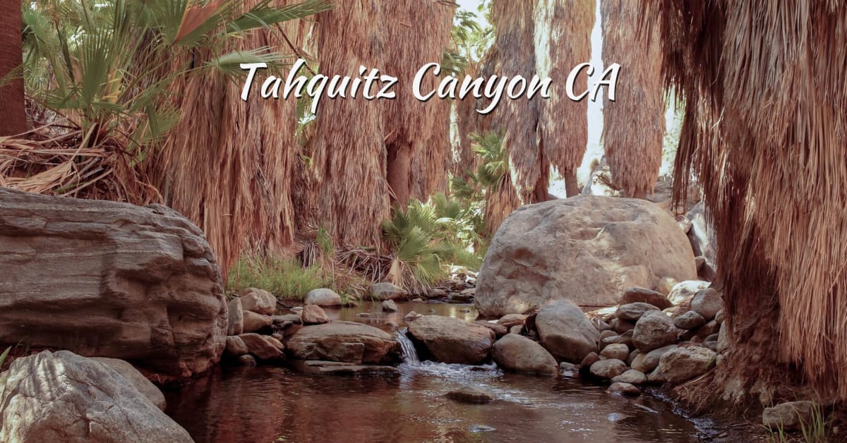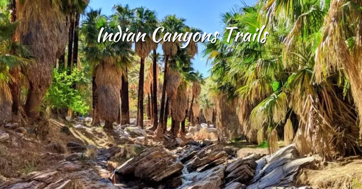
Indian Canyons is a beautiful ecological space just south of Palm Springs. The reservation land is operated under the ownership of the Agua Caliente Band of Cahuilla Indians.
The park extends over 31,500 acres, where visitors can admire canyon landscapes with their unique rock formations and attractive plant life. The Indian Canyons Trails wind through this incredible terrain, making it a top destination for hikers and nature lovers.
The Indian Canyons Trails provide an unforgettable experience that will stay with you long after your trip ends. So, put on your hiking shoes and set out to explore the Great Indian Canyons.
Introduction to Indian Canyons Trails: A Historic Desert Oasis
The land that became Indian Canyons served as home to the Agua Caliente Band of Cahuilla Indians for thousands of years.
Throughout time, the Cahuilla people built a prosperous history in this place because the canyons offered them access to vital water resources and sources of nourishment.
According to the Cahuilla people, strong spirits reside in these canyons to protect their tribe.
The Agua Caliente Tribe started their guardianship duties of natural territory during the early 1900s, which led to Indian Canyons securing nature reserve protections in 1969.
Guests today can walk or ride horses in these canyons to admire their natural scenery and learn about the cultural and historical heritage of the Cahuilla people.
Three major Indian Canyons Trails—Andreas Canyon, Murray Canyon, and Palm Canyon—offer unique perspectives of the canyon systems and their diverse surroundings.
The different hikes at the Indian Canyon deliver specific vistas of the canyon systems and adjacent terrain.
This beautiful environmental reserve delivers visitors precious knowledge about the Agua Caliente Band of Cahuilla Indians’ historical heritage while acting as their significant cultural and environmental domain.
Guests can explore over 60 kilometers of designated Indian Canyons Trails, immersing themselves in both the natural world and the story of a people who have cherished it for generations.
Why Visit the Indian Canyons in Palm Springs, California?
Visitors find at the Indian Canyons more than hiking trails because these beautiful spaces offer trouble-free access to cultural experiences and historical insights along with nature’s hidden secrets.
A complete overview of the destination reveals several compelling reasons to explore the Indian Canyons Trails.
- This land has served as the traditional territory of the Agua Caliente Band of Cahuilla Indians for generations, offering a deep cultural and spiritual significance.
- The Indian Canyons Trails guide hikers through striking desert scenery featuring historic palm groves, flowing streams, and impressive rock formations shaped by time.
- You can find diverse wildlife on the trail. Spot bighorn sheep, roadrunners, and various bird species along the trails.
- Many waterfalls scattered throughout the Indian Canyons Trails are at their most spectacular following seasonal rains, making each visit unique depending on the time of year.
Plan Your Visit to Indian Canyons Trails in Palm Springs CA
Planning a trip to Indian Canyons? You need to learn about the opening hours, directions, and tickets for a smooth visit.
Here is everything you need to know.
Indian Canyons Trails Opening Hours
Visitors can enjoy Indian Canyons throughout its seasonal hours because these operating periods serve both the safety needs of participants and environmental conservation goals.
- From October through June, the facility stays accessible from 8 am until 5 pm every day.
- Extreme summer temperatures require the seasonal schedule because hiking under these dangerous conditions becomes unsafe.
- Before visiting, check the official website to confirm whether staff has made any adjustments to their hours and potential closures.
Timing
| Date | Timing |
| Oct. 1 to July 4 | Daily 8 am to 5 pm |
| July 5 – Sept. 30 | 8 am to 5 pm |
Note: The last entry is at 4 pm.
Indian Canyons Trails Directions to enter
You enter Indian Canyons through South Palm Canyon.
- You will come to a toll booth and pay your entry cost.
- Then, all of Indian Canyons is accessible, with signage leading you to the three canyons.
Indian Canyons Trails Tickets
Both cash and credit card payments can be used at the toll station. Visitors should arrive early during weekend days because the parking area tends to reach capacity.
You can also book your tickets online before visiting, so you don’t have to wait in line.
Here is the ticket list:
| Categories | Prices |
| Adults | $12 |
| Seniors 62+ | $7 |
| Students | $7 (with student ID) |
| Children (6-12) | $6 |
| Military | Free (with U.S. military ID) |
| Equestrian | $11 |
Best time to visit Indian Canyons Trails
People visiting Indian Canyons Trails should plan their trip based on seasonal preferences and weather conditions for the best experience.
Spring (March to May)
Hiking conditions along the Indian Canyons Trails are ideal during spring, thanks to the pleasant weather. This season showcases blooming wildflowers and increased wildlife activity, making it a favorite among nature and photography lovers.
Fall (October to December)
Fall is a wonderful time to explore Indian Canyons Trails due to mild temperatures and fewer crowds. The golden hues of the palm trees and clear skies create perfect conditions for extended hikes and scenic photography.
Winter (January to February)
Winter brings cool, comfortable temperatures to the Indian Canyons Trails, with occasional rainfall that enhances greenery. The peaceful environment and minimal visitor traffic make it a tranquil time for a nature walk or cultural exploration.
Summer (June to September)
Hiking the Indian Canyons Trails in summer can be challenging due to extreme heat, often exceeding 100°F (38°C). During these months, the park operates on limited weekend hours. Early morning visits are essential to beat the heat and enjoy the landscape safel
Best Indian Canyons Trails for Every Adventurer – 2026
Explore a network of Indian Canyons Trails that wind beneath whispering palms and climb rugged mountainsides. Ride horseback through canyon terrain, join ranger-led hikes to learn about native flora and fauna, or simply find a peaceful spot to sit, relax, and meditate.
On a ranger-led hike, you’ll learn about the native flora and fauna. Find a quiet location to sit, relax, and meditate.
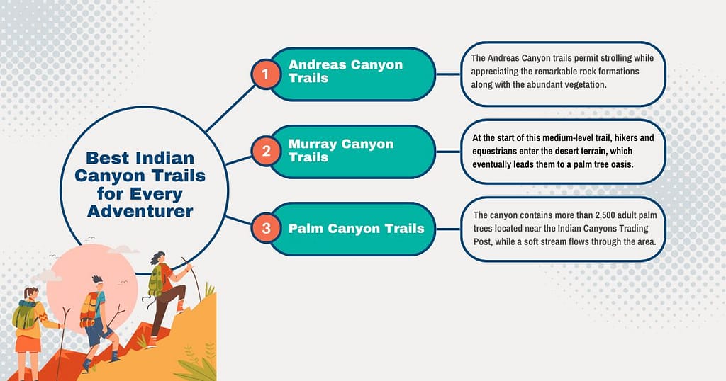
Andreas Canyon Trails
The Andreas Canyon Trails, part of the larger Indian Canyons Trails network, offer a peaceful hiking experience through remarkable rock formations and lush desert vegetation. Hikers can follow the canyon route past natural pools and gentle streams—ideal for cooling off or taking a break in the shade of towering palms.
You can enjoy hiking through the canyon while visiting natural pools and streams that attract numerous visitors for hiking and relaxing under trees.
You must follow the park guidelines of keeping all animals undisturbed by preventing feeding them.
A better option for footwear in such terrain is to choose closed-toe shoes over sandals.
Andreas Canyon Loop
The Andreas Canyon Loop, one of the most popular segments of the Indian Canyons Trails, is home to the second-largest native palm oasis in the world. Ancient rock mortars near the entrance stand as historical markers of early Cahuilla inhabitants.
- The trail begins at the Trail Information Board positioned just before the bridge to the north.
- The path moves west toward the north face of Andreas Creek for 0.5 miles before leaping across the water to continue its journey higher up on the streambank that connects to the parking entrance.
- Accompanied by harsh desert conditions, hikers are delighted by views of diverse natural features that include rock formations together with sycamores, cottonwoods, willows, and the majestic California Fan Palm (Washingtonian filifera).
About It
| Distance | 1 mile (round trip) |
| Duration | 30-40 minutes |
| Dificulty | Easy |
| Elevation Gain | 200 feet |
Andreas Canyon North & South Trails
Part of the popular Indian Canyons Trails system, the Andreas Canyon North & South Trails form a scenic loop perfect for biking and hiking enthusiasts. These designated trails connect the equestrian gate to the Andreas Canyon parking lot, making for a smooth and rewarding circuit.
- The trail follows the Andreas Canyon alluvial fan while giving riders views of desert plants along with geological features and panoramic Canyon vistas.
About It
| Distance | 2 to 2½ miles |
| Duration | 30 minutes |
| North Dificulty | Moderate |
| South Dificulty | Easy |
| Elevation Gain | 200 feet |
Maynard Mine Trail
One of the more challenging hikes within the Indian Canyons Trails network, the Maynard Mine Trail once served as the access route to historical tungsten mining operations. The trailhead starts at the south end of the Andreas Canyon parking lot, just beyond the bridge.
- The Andreas Canyon parking area hosts the trailhead on its south side, right after crossing the bridge.
- The track runs 1.4 miles west until it accelerates its ascent to reach the Murray and Andreas Canyons ridge top.
- The trail descends 0.5 miles across the ridge until it reaches the razorback ridge that contains the end of the trail marker.
- Exploring the mine entrance requires following the trail north across the ridge from its conclusion approximately 200 feet from the sign.
About It
| Distance | 6 miles |
| Duration | 5 hours |
| Dificulty | Hard |
| Elevation Gain | 2,080 feet |
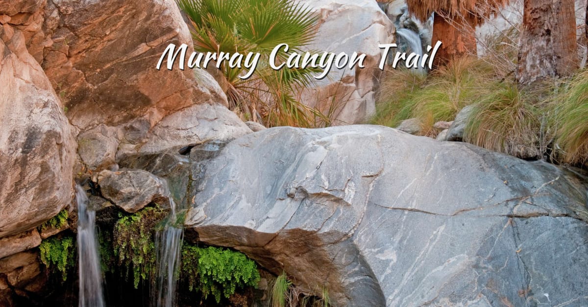
Murray Canyon Trails
Part of the scenic Indian Canyons Trails network, Murray Canyon Trails offer a rewarding adventure for both hikers and equestrians. This medium-level trail starts in a wide desert wash before gradually transitioning into a lush palm oasis.
You will cross a stream with water from the mountains more than twelve times as your ascent continues up the canyon.
The grand finale? The cascade runs as seasonal waterfall Seven Sisters occurs at this site.
Murray Canyon Loop Trail
This route is one of the standout features among the Indian Canyons Trails, especially during the cooler months. The creek that flows through Murray Canyon is seasonal, typically active from winter to early spring, providing a tranquil soundtrack for your hike.
- The path starts from the south end of the Andreas Canyon parking area and then takes hikers to the desert floor, where they can see remarkable rock formations before reaching the entrance of Murray Canyon.
- From the stream crossings, the path meanders for 1½ miles inside the canyon until the end arrives at Seven Sisters, which displays a 12-foot waterfall.
About It
| Distance | 4 miles (round trip) |
| Duration | 2 hours |
| Dificulty | Easy |
| Elevation Gain | 500 feet |
| Waterfall | Seasonal 12-Foot Waterfall |
Coffman Trail
One of the hidden gems within the Indian Canyons Trails system, Coffman Trail serves as the northern access point to the West Fork North Trail. Hikers can reach this trail via the Murray Canyon Trail, which runs for about 1¼ miles before meeting the Coffman junction.
- The Murray Canyon Trail leads hikers 1¼ miles until it reaches the intersection with the Coffman Trail, which then continues to a saddle that exhibits excellent desert viewpoints.
- Hikers can form a circular route around Andreas Canyon by utilizing the Coffman Trail.
About It
| Distance | 1¼ miles |
| Duration | 45 minutes |
| Dificulty | Moderate |
| Elevation Gain | 400 feet |
Alexander Trail & Alexander East Trail
The trail enables equestrian access from the tollgate entrance to reach Murray Canyon and Fern Canyon trails, as well as Victor and Palm Canyon trails.
- The Alexander Trail parallels Palm Canyon Road to the Horse Trailer Parking area.
- From the base of the Santa Rosa Mountain Range, the Alexander East Trail extends all the way to the Fern Canyon Trail Junction.
- The trail stands as an ideal pathway for adventurers who want a medium-level climbing adventure that reveals numerous beautiful sights and strange natural attractions.
About It
| Distance | 1½ mile to 1¼ miles |
| Duration | 45 minutes |
| Dificulty | Easy |
| Elevation Gain | 105 to 180 feet |
Palm Canyon Trails
As one of the most iconic Indian Canyons Trails, Palm Canyon Trails offer a steady and scenic walking path that winds through the largest naturally occurring palm oasis in the United States.
The canyon contains more than 2,500 adult palm trees located near the Indian Canyons Trading Post, while a soft stream flows through the area.
You can browse the store for refreshments alongside native art and artifacts and books and jewelry at the trailhead.
Palm Canyon Trail
Experience a hike through the world’s biggest California Fan Palm blossoming habitat. People who visit Palm Canyon can experience magnificent California Fan Palm forests as they traverse the scenic Palm Canyon Creek.
- The Cahuilla Indians used to live in what is now known as this creek area, which is revealed through rock mortars discovered on the site.
- Wandering hikers will find entry to different length trails from the Palm Canyon Trail launched at the Trading Post of Anza-Borrego Desert State Park.
- The Palm Canyon Trail enables visitors to reach West Fork Trail, East Fork Trail, Victor Trail, Vandeventer Trail, and Indian Potrero Trail as well as Dry Wash Trail.
About It
| Distance | 15 miles (one way to Hwy 74) |
| Duration | Up to 8 hours (depending on distance) |
| Dificulty | Moderate |
| Elevation Gain | 3,520 feet |
Victor Trail – Loop with Breathtaking Canyon ViewsVictor Trail
The trail stands among the best scenic trails in the Indian Canyons. The route to this trail becomes accessible after hiking one mile south on Palm Canyon Trail.
- Through the Victor Trail, you escape palm shade to climb the ridge above the canyon before the path returns hikers to the Trading Post for a total three-mile loop.
- The picture shows the trading post located in the distant scenes below.
About It
| Distance | 3 mile loop |
| Duration | 1 hour 30 minutes |
| Dificulty | Moderate |
| Elevation Gain | 250 feet |
East Fork Trail – A Moderate to Hard Scenic Adventure
The trail stands among the best scenic trails in the Indian Canyons. The route to this trail becomes accessible after hiking one mile south on Palm Canyon Trail.
- Through the Victor Trail, you escape palm shade to climb the ridge above the canyon before the path returns hikers to the Trading Post for a total three-mile loop.
- The picture shows the trading post located in the distant scenes below.
About It
| Distance | 3 mile loop |
| Duration | 1 hour 30 minutes |
| Dificulty | Moderate to hard |
| Elevation Gain | 550 feet |
Dry Wash Trail – Easy Connector to Dunn Road
Hikers must start hiking on Palm Canyon Trail toward the south and travel 2 ½ miles until reaching Dry Wash Trail.
- The Dry Wash Trail works as a path that links the Palm Canyon Trail with Dunn Road.
- Walking through the Dry Wash Path lets people reach the East Fork Loop Trail.
About It
| Distance | 3 miles from Palm Canyon to Dunn Road |
| Duration | Depends on the person to person |
| Dificulty | Easy |
| Elevation Gain | 850 feet |
Vandeventer Trail – Explore Ridge Views and Trail Intersection
Guests can access the Vandeventer Trail by starting from the Fern Canyon Trail or the Victor Trail.
- Travelers can reach this path through the Fern Canyon Trail, together with the Dunn Road Trail intersection.
- A 6-mile scenic trail loop becomes available when guests walk the Fern Canyon Trail followed by Vandeventer Trail and finish their return journey through Palm Canyon Trail to the Trading Post.
- The Vandeventer Trail gives hikers the ability to reach both Hahn Buena Vista Trail as well as the East Fork Loop Trail and the Victor Trail.
About It
| Distance | 2 miles |
| Duration | 1-½ hour |
| Dificulty | Moderate to Hard |
| Elevation Gain | 500 feet |
Fern Canyon Trail – Hike to a Shaded Fern Oasis
Visitors can reach the Fern Canyon Trail by entering through the lower Palm Canyon parking spot.
- From the starting point in the lower parking area, the trail climbs to reach the ridge where visitors can admire Fern Canyon then continues to a point where maidenhair ferns spread over the canyon overhang.
- While following the ridge path, the hiker experiences an amazing view of numerous desert flora that inhabit this space.
- In short the naturally dripping water shaped the ferns into a vast green expanse that covered the whole overhanging rock surface.
- Visitors enjoy this fern location because shady conditions always prevail in the area. Thus, the ferns maintain a refreshingly cool temperature. The Vandeventer Trail becomes accessible through the fern outcroppings, which creates a six-mile trekking option.
About It
| Distance | 2-¼ miles to Fern Canyon (one way) |
| Duration | 1 hour |
| Dificulty | Moderate to Hard |
| Elevation Gain | 600 feet |
Indian Potrero Trail – Discover Hidden Rock Pools & Plateau
The trail begins at the Palm Canyon Trail and Dry Wash Trail intersection, which is positioned two miles south of Trading Post.
- The journey proceeds to bring people to higher parts of Palm Canyon with its several rock pools for hikers to see.
- The path carries hikers up to an unseen plateau area that has its sides formed by the rocky environment into an organic grazing spot.
- The Indian Potrero Trail enables access to the Palm Canyon Trail when hiking from this concluding pasture region.
- The round-trip Palm Canyon Trail extends to the Trading Post with a total distance of 8 miles, showing agave and ocotillo along with the Teddybear Cholla during the return journey.
About It
| Distance | 8 miles (round trip) |
| Duration | 4 ½ hours |
| Dificulty | Moderate |
| Elevation Gain | 540 feet |
Hahn Buena Vista Trail – One of the Best High-Country Desert Hikes
Hikers will find this trail provides magnificent views as one of the prettiest high-country paths in the Santa Rosa Mountains range.
- During the summit hour visitors can see every direction across desert cities, along with all adjacent mountain ranges.
- A tough hike is to create an 11½ mile loop by taking the Fern Canyon Trail, the Dunn Road Trail, and the Dunn Road, then returning via the Hahn Buena Vista Trail to the Vandeventer Trail and the Palm Canyon hike to the Trading Post.
- Trained hikers represent the sole group who need to attempt this trail.
About It
| Distance | 11½ mile loop |
| Duration | 6 hours |
| Dificulty | Hard |
| Elevation Gain | 1,250 feet |
West Fork Trail – Tough Climb with Wildlife & Panoramic Rewards
The route presents a tough climb of 1,400 feet, which extends over a brief distance while providing exceptional payoff points.
- The hikers who demonstrate good fitness levels will discover breathtaking views at the summit point. Deep observation skills while hiking could lead to spotting either of the rare creatures like mule deer or shy Bighorn sheep.
- The Palm Canyon Trail functions as the starting point to reach this trai,l which is situated 900 feet south of the Trading Post.
- The West Fork Trail terminates when it meets Jo Pond Trail as well as West Fork North Trail.
About It
| Distance | 5 miles (round trip) |
| Duration | 3 hours |
| Dificulty | Challenging |
| Elevation Gain | 1,400 feet |
West Fork North Trail – 9-Mile Loop with Dramatic Elevation
The ideal way to experience the West Fork North Trail includes a 9-mile loop formed by connecting the West Fork trail to West Fork North trail with Coffman trail and Murray Canyon trail, and Alexander trail.
- The most advantageous way to begin this trail involves starting at the West Fork Trail. Walk the West Fork Trail from Palm Canyon for 2½ miles to find the trail junction between Jo Pond and West Fork North Trails.
- Proceed to the West Fork North Trail by turning right and heading north, or stay straight to enter the Jo Pond Trail.
- Travel up the West Fork North Trail until you reach a spectacular 2,600-foot elevation, which grants you a perfect view of the entire Indian Canyons area.
- Proceeding from the West Fork North Trail involves descending to Coffman Trail which connects to Murray Canyon Trail until you reach the service road leading to Alexander Trail and Palm Canyon Road to return to the Trading Post parking area.
About It
| Distance | 9 mile loop |
| Duration | 5 hours |
| Dificulty | Challenging |
| Elevation Gain | 1,500 feet |
Jo Pond Trail – Epic 18-Mile Journey to Garnet Ridge
The Jo Pond Trails extend from the West Fork Trail until it reaches the Pacific Crest Trail resting on Garnet Ridge.
- The trail moves through steep elevation changes with its vigorous ascent towards the top, which results in a total elevation climb of 4,600 feet.
- Prior to reaching their destination on the Pacific Crest Trail, explorers have the chance to see the Palm to Pine ecosystem evolution from desert to mountains at Jo Pond Trail.
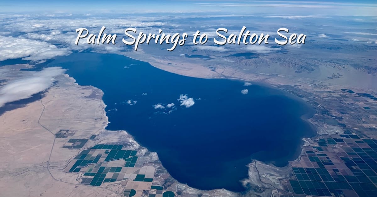
- During clear conditions hikers can see expansive views of the Coachella Valley combined with the Salton Sea alongside them.
- Travelers consider this trail to represent one of the most amazing routes within the area.
About It
| Distance | 18 miles (round trip) |
| Duration | 9 hours |
| Dificulty | Challenging |
| Elevation Gain | 4,600 feet |
Beyond the Trails: What Else to Do in Indian Canyons
Indian Canyons attracts most visitors through its beautiful hiking distances but contains numerous hidden treasures.
Visitors will have a comprehensive experience when they visit this destination since it showcases seasonal waterfall sites alongside cultural spots and hot mineral thermal pools.
Discover the Waterfalls of Palm Springs Canyons
The natural attraction at Indian Canyons, which few visitors know about are the waterfalls that appear during certain seasons. The desert transforms into an oasis through waterfalls that receive their source from winter and spring rains.
Experience a Cultural Oasis in the Desert
Indian Canyons serves as a place that displays natural beauty, which stems from its essential cultural importance to the Agua Caliente Band of Cahuilla Indians. People visiting Indian Canyons gain insight into the indigenous history of this land through their exploration of cultural heritage.
Agua Caliente Hot Mineral Springs
The Agua Caliente Cultural Museum serves as the essential landmark for anyone wanting to comprehend the heritage of the Agua Caliente Band of Cahuilla Indians. Visitors can discover the historical timeline of the future of the Agua Caliente Band of Cahuilla Indians at the Agua Caliente Cultural Museum, which stands in downtown Palm Springs.
Travel Tips for Hiking Indian Canyon Trails Palm Springs CA
The provided travel tips will benefit both experienced hikers alongside new walkers who seek beauty-filled hikes.
Plan Your Visit in Advance
Indian Canyons falls under the management of the Agua Caliente Band of Cahuilla Indians while following definite operational hours. Read the official website to determine scheduled operational times and payment requirements. You should plan your visit during the months from October to April because the weather remains cooler.
Start Early
Summer brings scorching temperatures, which make Palm Springs one of the hottest cities. The early part of the day offers optimal conditions for hiking at Indian Canyons because temperatures are mild, and crowds tend to be less substantial.
Dress for the ocassion
You should wear moisture-repelling light fabrics combined with durable hiking footwear that provides solid grip features. To extend your sun protection exposure, you should wear a hat together with sunglasses and a lightweight long-sleeve shirt.
Stay Hydrated and Bring Snacks
Desert trails demand larger water quantities compared to hiking in different environments. Each person should bring at least 2 liters of water together with high-energy snacks, including nuts, protein bars, and dried pieces of fruit.
Respect Nature and Wildlife
Various bird species and bighorn sheep, and lizards reside within the boundaries of Indian Canyons. Traverse marked paths while adhering to the principles of Leave No Trace and keeping a prolonged distance from animals.
Pack the Essentials
Carry a small backpack with:
- Sunscreen
- First-aid kit
- Map or GPS
- Extra water and snacks
- Camera or binoculars for sightseeing
Understand Cultural Significance
The Agua Caliente Band of Cahuilla Indians considers Indian Canyons to be their sacred indigenous ground. People must show reverence to cultural sites while refraining from touching uncovered rock art and abiding by displayed safety rules.
Watch for Trail Conditions
Dangerous trail conditions include flash floods as well as loose rocks, and temperatures reaching extreme heights. Always inspect local trail conditions as well as weather information whenever you plan to visit.
Enjoy the Experience
When visiting Indian Canyons, spend time both admiring its fantastic sights and hearing natural sounds while fully experiencing the canyon’s splendor. Each trekking route through this terrain provides visitors with an unforgettable, unique encounter.
Where to Stay: Spirit of Sofia – Your Ideal Base for Indian Canyon Adventures
After visiting Indian Canyons, the Spirit of Sofia is the perfect destination to unwind in a relaxing atmosphere.
- You can reach the canyons with ease due to its favorable location.
- Here, you will find luxury amenities. Relax in comfortable rooms, a tranquil pool, and a rejuvenating spa.
- You can also use wellness services at the resort, which include specialized yoga sessions, meditation classes, and hiker-specific spa treatments.
Conclusion | Indian Canyons Trails
Indian Canyons serves as a sanctuary for people who love nature alongside culture and impressive scenery.
People from various experience ranges can find adventure at this site through relaxed palm-covered walks or intermediate wildflower hikes, or strenuous ridge climbs.
The groves and hills of the canyons preserve the historical and ancestral traditions of the Agua Caliente Band of Cahuilla Indians, which give visitors a chance to study the tribe’s cultural legacy.
The luxurious Palm Springs sanctuary Spirit of Sofia provides the ideal lodging option because it offers refined comfort with wellness retreats alongside a relaxing desert atmosphere.
FAQs | Indian Canyons Trails
1. What are the Indian Canyons?
Indian Canyons are a group of scenic canyons located in Palm Springs, California, managed by the Agua Caliente Band of Cahuilla Indians. They include Palm Canyon, Andreas Canyon, and Murray Canyon, offering some of the best hiking in the region.
2. Do I need a permit or ticket to hike in Indian Canyons?
Yes, there is an admission fee to access the Indian Canyons. Tickets can be purchased at the entrance gate. The fees support the maintenance and preservation of the area.
3. What are the best hiking trails in Indian Canyons?
Top trails include:
- Palm Canyon Trail (moderate, 15 miles total, or shorter out-and-back options)
- Andreas Canyon Trail (easy, 1-mile loop)
- Murray Canyon Trail to Seven Sisters Waterfall (moderate, 4.7 miles round trip)
4. What should I bring for a hike in Indian Canyons?
Bring plenty of water, sun protection (hat, sunscreen), sturdy hiking shoes, and a trail map or GPS. Cell service may be limited in some areas.
5. Are the Indian Canyons trails suitable for beginners?
Yes, especially the Andreas Canyon Trail, which is a short and easy loop suitable for families and beginners.
6. Is there shade along the trails?
Yes, especially in Andreas Canyon and parts of Palm Canyon where you’ll find California Fan Palms and lush oases providing shade. However, many areas are still exposed, so plan accordingly.
7. Are the Indian Canyons open year-round?
Generally, yes, but summer temperatures can be extreme. The best time to visit is between October and April. Always check current conditions before visiting.
8. Can I bring my dog to Indian Canyons?
No, pets are not allowed on the trails to protect the native wildlife and preserve the natural environment.
9. Are there waterfalls in Indian Canyons?
Yes, the Murray Canyon Trail leads to the beautiful Seven Sisters Waterfall, best viewed in winter and early spring after rainfall.
10. Is there parking available at Indian Canyons?
Yes, there is ample parking available near the visitor center and trailheads.
11. Are guided hikes available?
Yes, the Indian Canyons often offer ranger-led or guided hikes. Check with the visitor center for availability and schedules.
12. What is the elevation gain on Indian Canyons trails?
It varies:
- Palm Canyon Trail: up to 800 ft gain depending on the route
- Andreas Canyon Trail: minimal elevation
- Murray Canyon Trail: approx. 500 ft gain